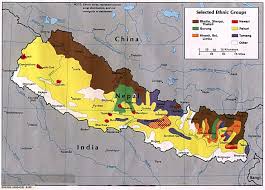
The kingdom of Nepal is a landlocked country which lies along the southern slopes of the Himalaya
Mountains, with India on its southern, eastern, and western borders, and the Tibetan Autonomous
Region of the Peoples' Republic of China to the north. The country has a land area of 147, 180km
2,
being 800km from east to west, and varying from 144km to 240km north to south, between
longitudes 80°–88°E and latitudes 26°–31°N. Within Nepal's borders lie some of the most deeply
incised and geologically active regions in the world, and over 70% of the country is covered by
mountains of varying altitude.
Three main physical regions can be defined based broadly upon altitude. To the south of the country
is the Terai which is low, 50–100masl, and is a northern extension of the Gangetic Plains of India.
The topography of the area is flat, and the soils are generally very fertile, consisting of alluvial
deposits carried down in the rivers from the hills and mountains to the north. This zone ranges from
25–32km in width.
Rising from the Terai plains and following an east/west alignment, are two ranges of hills generally
referred to as the “Mid-hills” which range in altitude from 1300–2500masl and which are known as
the Siwalik (or Churia) Hills at lower altitudes and the Mahabharat Lekh range at higher elevations.
Between the Mahabharat Lekh and the high Himalayas are another series of mountains commonly
referred to as the “High-hills” which cover the elevations from 2500–5000masl, these being a
transitional zone and aligned generally north/south as a result of the rivers draining through them
from the high Himalayas. To the north of these High-hills are the Himalayas proper, again aligned
east/west, which include the highest mountains in the world and range from 5000–8800masl. These
last two zones are either only sparsely inhabited, or are totally uninhabited, with most land above
5500m being permanently snowbound.
It follows, that the climate and therefore the natural environment of the country are influenced by two
factors. First, Nepal is situated in sub-tropical latitudes so that temperatures at low altitudes are
inherently warm to hot. Superimposed upon, and modifying this potentially subtropical climate are
both the effects of altitude and aspect, which result in great diversity of microclimatic conditions with
respect to temperature and rainfall, so that the natural environment can show great variation within
a particular location.
The climate of the Terai is subtropical, with the natural seasons being determined by the monsoon
rains which affect the entire Indian subcontinent. As the low to mid-hills (1300–2500masl) are
encountered, the climate is classified as warm temperate, and above this, between 2500 and 4500masl
cool-temperate. The high hills (2500 to 5500m), comprise an alpine zone, while above 5500m, the
temperature is almost always below freezing point.
Rainfall varies from as little as 500mm per annum in the rainshadow areas to the north of the high
Himalayas to over 5000mm in areas to the south of some of the major Himalayan massifs. For most
of the country average rainfall lies between 900mm and 1900mm per annum, becoming progressively
drier from the east to the west. The greater part of this rain falls during the monsoon between the
middle of June and the end of September.
Under such conditions of climatic variability there is a wide diversity of climax vegetation. Where
the climate is subtropical on the Terai and in the lower hills, then tropical forest trees such as khair
(
Acacia catechu), sissoo (
Dalbergia sissoo), and sal (
Shorea robusta) are the dominant species. In the
mid-hills, deciduous trees such as poplars (
Populus spp.), oaks (
Quercus spp.), walnut (
Juglans regia)
and larch (
Larix spp.) in association with evergreens such as pines (
Pinus spp.) and rhododendrons
(
Rhododendron spp.) predominate. Between 3000–4000m asl, rhododendron, mixed with birch (
Betula
spp.) and fir trees occur, while the zone below the timber line of the high mountains contains spruce,
fir, cypress, juniper and birch. Alpine pasture occurs at high altitude below the permanent snowline
(4500–5000m asl) and has traditionally afforded valuable grazing land during the summer monsoon
months.
At present, about one third of the country is still covered by natural forest, but most of this is
confined to the less accessible slopes of hills and mountains. On the Terai, there has been severe
overexploitation of natural sal woodland leading to its degradation and consequent loss of land use
potential, through physical erosion of the soil, and a decline in its fertility.
In geological terms, Nepal is still a young country, and the theory of plate tectonics asserts that the
Indian subcontinent is still moving northwards with the result that the Himalaya Mountains are still
rising. The hills and mountains abutting the Himalayan Massif are still geologically active, and
regular earthquakes of considerable magnitude are a feature of the country. The mountain and hill
slopes are therefore steep and inherently unstable. Even without human intervention, landslides and
other mass movements of soil are frequent, particularly during the monsoon season, when rainwater
water percolates down to the bedrock, and acts as an effective lubricant.


 Dhaulagiri is the seventh highest Mountain
 Cho Oyu
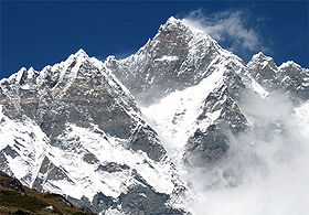
is the sixth highest mountain in the world, located a short distance to the
west from Everest (the highest) and Lhotse (the fourth highest) in the
Khumbu region of Eastern Nepal along the Tibetan border. Its towering peak
stands with Everest well above the surrounding mountains. It became a
familiar landmark to climbers ascending Everest's north face. Just west of
Cho Oyu is the Nangpa La, a 19,000-foot glacier pass, the main trade route
between the Khumbu Sherpas and Tibet.
Cho Oyu
is the sixth highest mountain in the world, located a short distance to the
west from Everest (the highest) and Lhotse (the fourth highest) in the
Khumbu region of Eastern Nepal along the Tibetan border. Its towering peak
stands with Everest well above the surrounding mountains. It became a
familiar landmark to climbers ascending Everest's north face. Just west of
Cho Oyu is the Nangpa La, a 19,000-foot glacier pass, the main trade route
between the Khumbu Sherpas and Tibet.
 The Kanchenjunga is also the mountain of Nepal which is located eastern part of Nepal. It has also its own importance like Mt.Everest. Mount
Kanchenjunga is one of the world's most spectacular mountains. It is renowned as
the queen of mountains. Kangchenjunga is the third highest peak on the planet,
can boast of varied ecological zones, from the subtropical land to glacial
wilderness. Mighty Kangchenjunga glacier is the most famous attraction of
Kanchenjunga. Great valleys, encircled by high
The Kanchenjunga is also the mountain of Nepal which is located eastern part of Nepal. It has also its own importance like Mt.Everest. Mount
Kanchenjunga is one of the world's most spectacular mountains. It is renowned as
the queen of mountains. Kangchenjunga is the third highest peak on the planet,
can boast of varied ecological zones, from the subtropical land to glacial
wilderness. Mighty Kangchenjunga glacier is the most famous attraction of
Kanchenjunga. Great valleys, encircled by high